
2.184 HEW c1880 RAI BHM 1931 B28
Plan showing surrounding features and a local land-owner
Material: tracing paper Scale: 2 chains per inch Size: c.100*40 cm
Condition: very poor
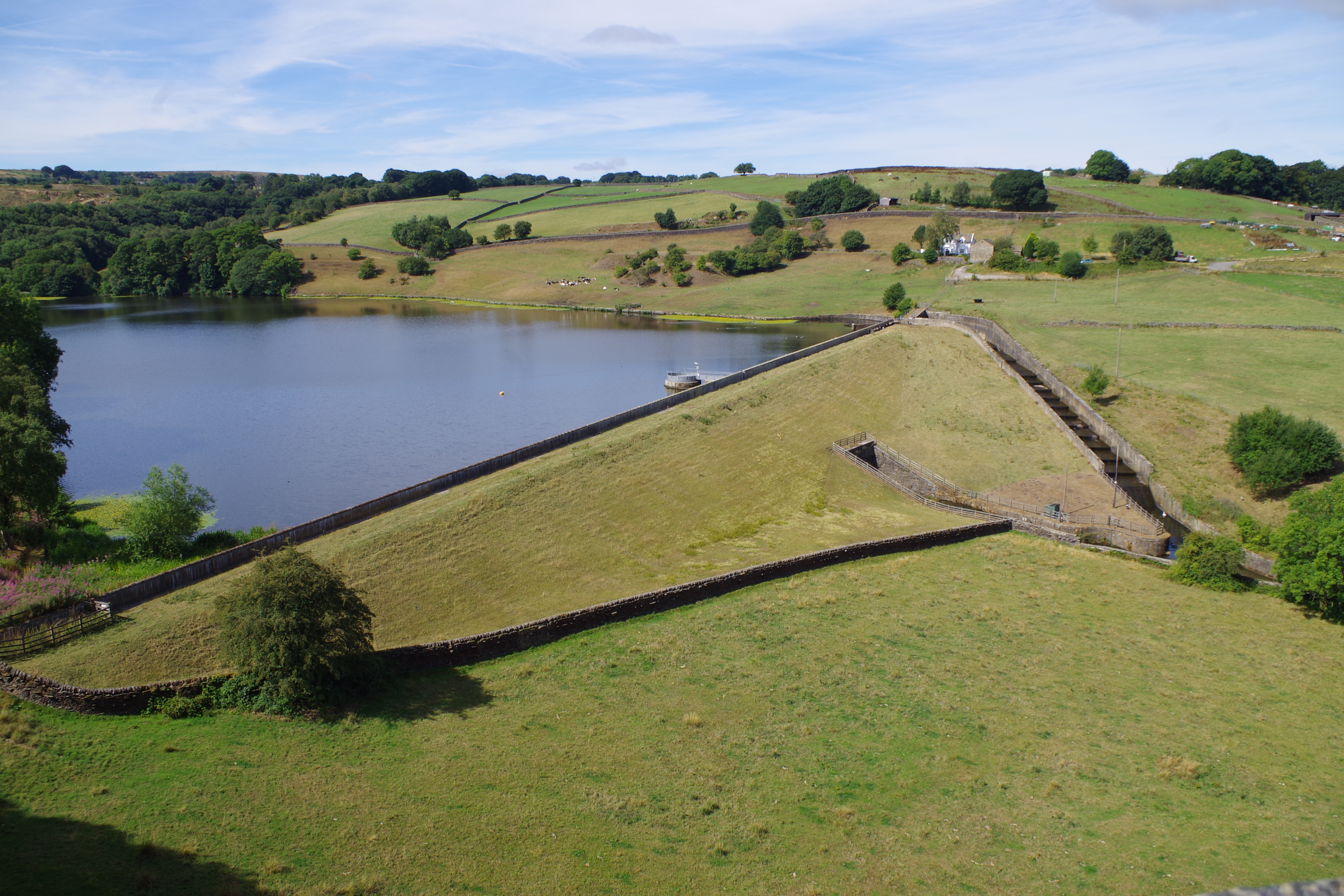
Some of the plans in the LSL reserve collection are in very poor condition indeed; they would require a skilled paper conservator to restore them to life. This is particular true of those drawn on a tan coloured 19th century tracing-paper which the passage of 150 years has made rather brittle. For many a photograph of a detail, together with a general description, will have to suffice. This is the case with the present plan showing the relationship between Hewenden reservoir and viaduct, near Cullingworth.
In the 1880s a new railway link was planned between Bradford and Keighley, via Queensbury and Thornton. This was finally opened in 1883. The plan may have been needed to indicate the land required for the tracks and viaduct. It must have been one of a long series of such plans which would have dealt with the whole line. The viaduct itself is well over a hundred feet high and is 576 yards long. It has 17 stone clad brick arches and its position was chosen to take the line round Many Wells, which was then an important source of water for Bradford. It was not the only important structure on the line for there is another magnificent viaduct at Thornton, with tunnels at Well Head and Lees Moor (between Cullingworth and Ingrow). When you reflect that the whole length of the route is not much more than 15 miles it is hard not to admire the courage of both the Victorian railway engineers and the financial backers of GNR. The line closed in the 1960s but the Hewenden Viaduct survives and today is a Grade II listed structure which it is possible to cross on foot.

The plan detail shown is aligned approximately north-south. It shows the northern end of the reservoir. This was planned by the Bradford Water Works Company in the early 1840s and seems to have been part of a development which included Chellow Dean (storage reservoir) and Whetley Hill (service reservoir), with all the necessary pipework. As far as I can tell the BWWC abstracted drinking water from the nearby Many Wells Springs with Hewenden being constructed as a compensation reservoir for the mill-owners downstream previously using the unrestricted water flow, such as Hewenden Worsted and Corn Mills and Hallas Worsted Mill. The compensation water discharged from the reservoir was first known as Hewenden Beck: thereafter it is called Hallas Beck, which flows through the lovely Goitstock Woods, and finally Harden Beck under which name it joins the Aire. The construction of the reservoir, which was filled by Denholme Beck, seems to have been the most contentious part of the whole scheme. It features prominently in contemporary editions the Bradford Observer whose agents were once threatened by a watchman with a stick when they turned up to investigate the subsidence of its earth embankment in 1845! These press reports suggest that the reservoir was fully functional by the early 1850s although the mill-owners may still not have been satisfied that they were getting adequate water supplies.
The plan shows clearly where the Hewenden Stream emerges from under the embankment with an additional overflow provided for when the water-level was high. Also marked is an unnamed quarry which probably supplied some of the reservoir stonework, and the line of Bradford’s main water-pipes from Many Wells Springs and Troopers Farm, which are just off the bottom right of the image. In the late 19th century the farm was occupied by one Edward Pickles. He featured in an important legal case known as Bradford Corporation v. Pickles, 1895. Seemingly water percolated beneath Pickles’s land at Troopers Farm, Many Wells and flowed into Hewenden reservoir. As I said Bradford used this water for their city supply. Actuated by a wish to make the corporation to buy his land Pickles obstructed the flow of water by sinking shafts into it. The court decided it was legal for him to take this action on his own property even if his desire was malicious. Bradford was forced to buy his property, and Pickles emigrated to Canada.
The line taken by the viaduct is clearly shown in blue. The other half of the plan is too damaged to photograph but shows the continuation of the railway line, a group of cottages called Spring Row, and the name of a local land-owner called Holmes Pickles (1832-1874). I am limited as a family historian but I believe that this man farmed 65 acres and was the father of Edward Pickles.
It is possible to visit the site today and, as the photographs will show, things don’t seem to have changed much:


It’s Manywells, not Many Wells. Apparently a contraction from Emanuel’s Wells which became Manny’s Wells and then Manywells.
LikeLike
I think it changed from Many Wells to Manywells over the years – I recall the act of parliament authorising construction and extraction using the former spelling when I looked.
Troopers farm and Manywells Spring are off the lower left of the map, not the right.
Troopers farm can be seen in the photo (white building nearest the reservoir) and the site of the troublesome mineshaft is in the clump of trees next to a barn (now capped with a concrete block), above and to left of the farm building in the photo.
Manywells spring is just on the reservoir side of the stone wall infront of those trees, various manhole covers can be seen at the location.
After the shaft was built it affected the water table (puncturing an impermeable later of rock) they had to dig deeper to tap into the water (and reducing quantity)
LikeLike